Client Login Area
Log In
  • 028 9081 7999
  • twilson@scadin.com
  • UPDATES
    • Scadin launch our new website
    • Now Scanning all Projects with our new Leica P40 HD Laser Scanner
    • Have your building or structure laser scanned and modeled in Revit
  • Client Area

Logo

  • Home
    Welcome
  • About
    Who We Are
  • Services
    What We Do
    • 3D Laser Scanning
    • Topographic Surveys
    • Measured Building Surveys
    • Utility Tracing
    • Setting Out
    • Monitoring & Precision Levelling
    • Boundary Disputes
  • Resources
    Useful Things
    • Frequently Asked Questions
    • Portfolio Examples
    • Scadin Videos
    • Useful Links
  • Contact
    Get In Touch
  • Welcome to

    Scadin Surveys Ltd

    One of the leading Architectural & Land Surveying companies within Northern Ireland.

  • Wide Range of Surveys

    Utilising The Latest Technology

    Many years experience of combining traditional and state-of-the-art surveying methods.

  • A Full Range of

    Laser Scanning & Digital Drawing Services

    Providing a highly accurate layout and comprehensive information for all requirements.

  • State of the Art

    Leica Equipment

    Scadin can reproduce any building or terrain electronically enabling Architects, Engineers and Designers to pursue their vision with confidence.

  • Dimensionally Accurate

    Point Clouds in Full 3D

    The scanner records three-dimensional positions at a predetermined resolution (1mm upwards) over a chosen area, generating thousands of high-accuracy coordinates.

Scadin is one of the leading Architectural and Land Surveying companies within Northern Ireland with over 20 Years of Trusted Measurement

  • Welcome to Scadin
  • Laser Scanning

Image title

Scadin is one of the leading Land Surveying companies within Northern Ireland.


Working extensively throughout the UK and Ireland on a variety of Conservation, Retail, Commercial and Government projects.

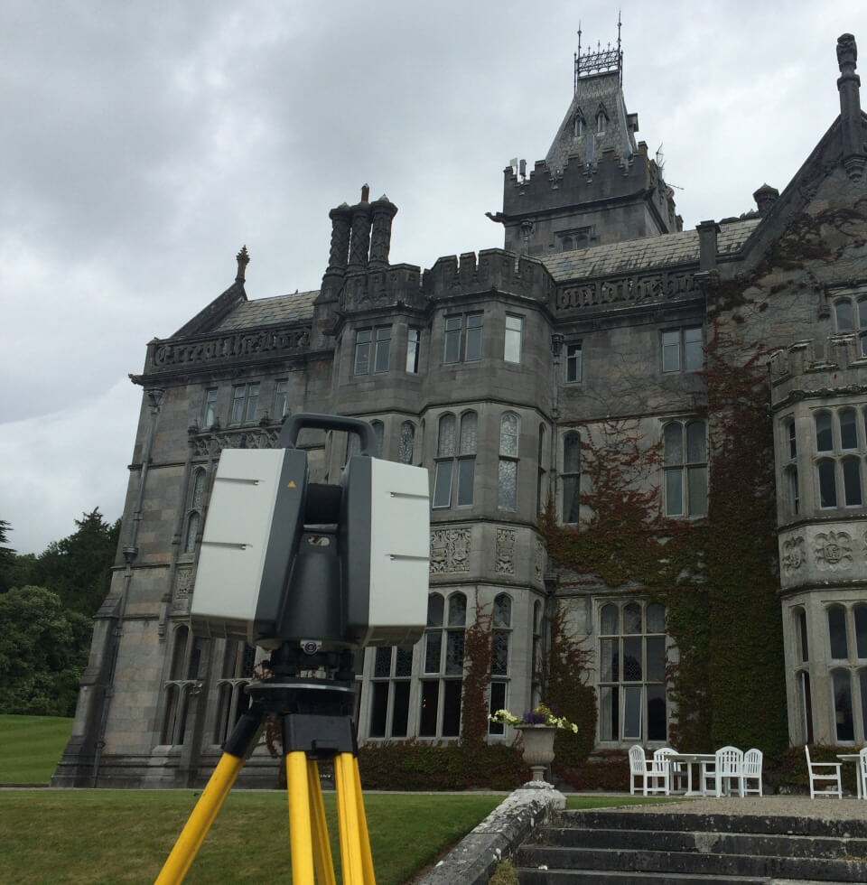
Utilising state of the art Leica Equipment including our C10 and P40 High Definition Laser Scanners measuring up to 1,000,000 points per second. Our 1200 and TS15 robotic stations and our GS 14 and GS15 smart net GPS systems , Scadin can reproduce any building or terrain electronically enabling Architects, Engineers and Designers to pursue their vision with confidence. 


Scadin is registered with constructionline as a pre-qualified supplier.

Laser scanning is changing the way surveyors work and collect data. In the past, the survey of a building or structure required the use of a Total Station to record chosen three-dimensional positions. These would then be processed in AUTO CAD and used to generate elevations. With laser scanning this has fundamentally changed. 


The scanner records three-dimensional positions at a predetermined resolution (1mm  upwards) over a chosen area, generating thousands of high-accuracy coordinates. The surface of a scanned structure is then represented as a dimensionally accurate point cloud in full 3D. In the  drawings shown here you can see that details at high levels can be accurately drawn.

Why Choose Scadin?

  • Over 20 years of experience working extensively throughout the UK and Ireland
  • Work has included a variety of Conservation, Retail, Commercial and Government projects.
  • One of the leading Architectural - Land Surveying companies within Northern Ireland.
  • Registered with constructionline as a pre-qualified supplier
  • Utilising state of the art Leica Equipment
  • Enabling Architects, Engineers and Designers to pursue their vision with confidence
  • img

    Setting Out Services

    Setting Out Services

    Setting out can be carried out in many ways depending on the clients needs.

    More Info
  • img

    3D Laser Scanning

    3D Laser Scanning

    Laser scanning is changing the way surveyors work and collect data.

    More Info
  • img

    Boundary Disputes

    Boundary Disputes

    We can mark out measured boundary lines, provide Ordnance Survey and Land Registry recognised plans.

    More Info
  • img

    Measured Building Surveys

    Measured Building Surveys

    Specially trained technicians using state of the art measuring equipment and handheld I.T.

    More Info
  • img

    Topographic Surveys

    Topographic Surveys

    Our surveyors use the latest survey technology from Leica Geosystems.

    More Info
  • img

    Utility Tracing

    Utility Tracing

    A GPR survey measures variation in sub-surface conditions.

    More Info
View All FAQs

Working extensively throughout the UK and Ireland on a variety of Conservation, Retail, Commercial and Government projects.

Our Office Details

Telephone: 028 9081 7999 Fax: 028 9081 7936 Email Address: twilson@scadin.com Postal Address: Unit 11, McKibbin House, Eastbank Road, Carryduff, BT8 8BD

Scan our QR code with your smartphone to save all our details.

Key Sections

  • Home
  • About
  • Services
  • Resources
  • Contact
  • GDPR 2018 Privacy Notice
  • Terms & Conditions

Get In Touch

© 2022 Scadin Surveys Limited. All Rights Reserved. Company No. NI055025.